

A major cold front will bring a significant cold snap to the region, including the coldest temperatures since mid-February.
The last time Cornelia dropped below 20 degrees was February 22 of this year. In fact, we’ve only had 11 days at the airport officially below 20 since the beginning of the year. We will likely add one more day to that total on Sunday night behind our next significant cold front.
This strong front will move through the region overnight Saturday bringing with it some isolated showers across the region. The front will most likely move through around 3-4AM and temperatures will begin to fall quickly afterwards. Some of the rain showers will turn to snow at higher elevations, and I can’t rule out flurries region-wide from 8-10AM on Sunday as the dry/cool air begins to quickly squeeze out all remaining moisture. High temperatures on Sunday will occur at midnight with temps falling or steady through the day.
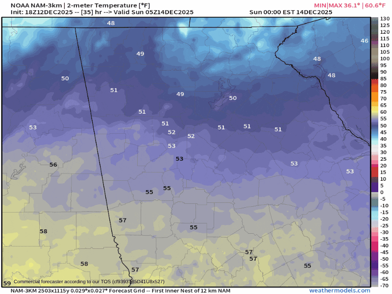
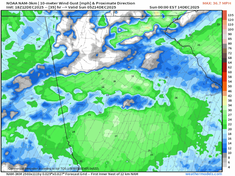
Temperatures will start off in the 30s in the mountains at midnight and quickly drop into the 20s by 8-9AM. Outside the mountains, temperatures will likely “bottom out” around 33-38° for most of the day. Winds will also become very gusty behind the front. Winds will be strongest in the mountains where gusts of 35-40MPH are possible at higher elevations, with the rest of the region seeing gusts of 30-35MPH possible. The strongest winds will occur around lunch on Sunday before they gradually drop off.
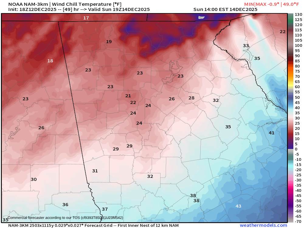
Wind chills will fall into dangerous territory across the mountains on Sunday afternoon. Values of 5-10° are possible through the morning and afternoon hours. Areas outside the mountains will see wind chills of 20-25°. By evening, wind chills could dip below zero in the mountains and into the low teens for the rest of the region. You’ll certainly want to bundle up, especially over the mountains.
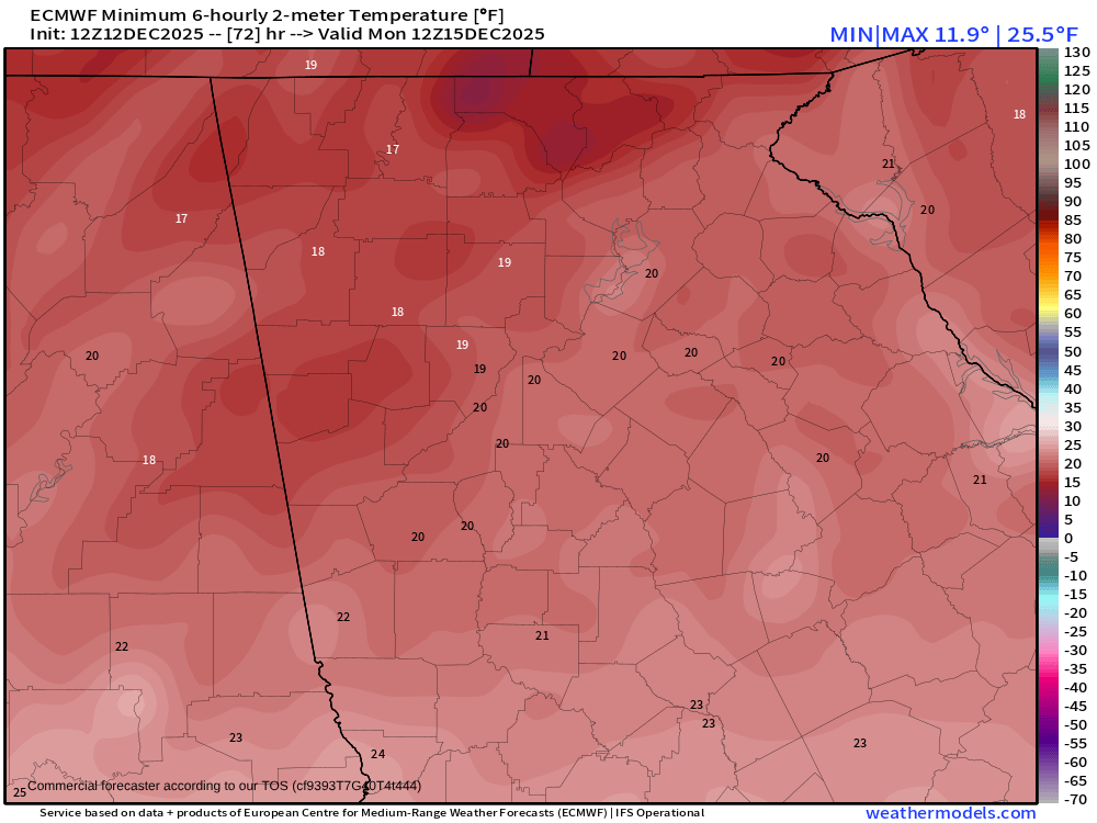
As the winds calm down, temperatures will really tumble into Monday morning. Widespread lows in the teens are expected across Northeast Georgia, and some single digits are possible in the mountains, particularly in Fannin County.
Temperatures will moderate very, very quickly beginning on Monday. Afternoon highs will remain very chilly, only in the 30s in the mountains and around 40 elsewhere, but overnight lows Monday night will top out around 10 degrees warmer for most only in the low/mid-20s.
With this cold snap moving in it’s a great time to remember the 4 P’s:
People: Check on any elderly people in your life who may need help keeping the heat running.
Pets: Bring pets indoors; they don’t want to be out in single digit wind chills and it can be dangerous. Unless they are a husky or other cold weather breed, it is best to bring them in overnight.
Pipes: Cover all exposed outdoor pipes. A simple Styrofoam cup taped over exterior spigots can do wonders for preventing freezing/busting. Fortunately, this is a relatively quick cold outbreak but it only takes a few hours below freezing, especially in the teens, to cause issues.
Plants: In the off chance you still have plants outside you’d be best to bring those in as well.


