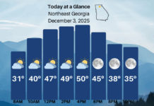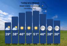
We remain in a very active weather pattern that will bring repeated rain chances through the weekend. We’ve just gotten past our first storm of the week, and now our attention turns to the next.
Wednesday will be dry, with varying cloud conditions across the region. The opposite of yesterday, those to the southeast of the mountains should see more clouds than those to the northwest. Highs will reach into the low-50s for most. Clouds will begin to increase tonight and especially Thursday as another low pressure system develops in the Gulf. Unlike last time, the weather models are quite split on the strength of this system(s). An initial wave of low pressure will spread moisture north on Thursday night into Friday. Friday will be very raw/miserable with rain likely and highs only in the low-40s.
The big question then becomes what happens with Saturday. The Euro model shows a much stronger low pressure system than the GFS, and would indicate much more widespread rain. On the other hand, the GFS with the weaker system actually keeps showers into Sunday across the area. With either solution rain is possible, if not likely, on Saturday and Sunday is up in the air. For now, I tend to agree with the Euro and a more organized Saturday system.
These very active patterns like this result in these types of situations a lot, so stay tuned!


